When I took Meg out for a walk this morning I saw this mess on the pontoon near our fore-end.

I’d like to have seen the angler who left that behind! Not to give him a piece of my mind, but to get a photograph. The culprit was one of a pair of otters who live on the lock island. We must have disturbed his breakfast.
After last night’s showers the air felt damp and there was a brisk wind blowing, so I decided to light the stove this morning. I recovered the chimney from it’s summer storage in the front locker and it tried to fall in bits in my hands. I did manage to wedge it on, but it’s not looking very well.
Sad looking chimney

I think a replacement is on the cards…
We got away about 10 o’clock, out of the lock cut and back onto the river.
Leaving Linton Lock

There’s an RAF airfield just north, and we were entertained by the training flights of the budding pilots.
A pair of prop aircraft in formation…

…and for the more advanced, something a little faster.

We had beautiful blue skies behind, but ahead it looked rather more threatening.
Looks like we’re going to get wet…

And we did. But only for 15 minutes or so.
At a bend west of Linton, Ouse Gill Beck flows in from behind a floodgate, and upstream from here the river is known as the Ure. It doesn’t look any different.
We’re on the URE!!

If it wasn’t for the wind, today’s cruise would have been very enjoyable. As it was I was glad to see sheltered stretches like that above. On the exposed water it was decidedly chilly!
Not many bridges today, just two if you don’t count the lock bridge at Milby.
Aldwark Toll Bridge sounds decidedly rattly as cars cross over.

This crossing was originally made in 1772, the local ferryman, fed up of losing trade when the river was in flood applied for and was granted an Act of Parliament to build the bridge. The Act also granted him the right to collect tolls.
Despite several changes of ownership, the Act is still in force, and the current toll for a car is 40p. Still, it saves a 25 mile round trip.
Obviously, this isn’t the 18thC original. That was damaged in the 19thC after, local legend has it, being hit by an iceberg! The replacement was built to the same dimensions, so it’s single track with a 7½ ton weight limit.
There’s a footbridge near Aldwark, then the river swings around the village of Lower Dunsforth before the River Swale joins from the right bank.
The river is remote, just gazing land on either bank, but there’s no real opportunity to moor against the high banks.
Although there’s always a way if you try hard enough…

I guess the owner of this one didn’t take enough care.

It looks like efforts are being made to recover it. If you click to enlarge you’ll see the cabin is filled with ICB’s, re-usable chemical containers, presumably as floats. When the river rises next I assume they’ll try to right it as it floats off, then pump out the water.
That’s the Swale, we bear left here.

I suppose the naming of rivers is basically arbitrary. The Swale appears to be the main route, with the Ure coming in from the left. Although the Ure is longer, it’s about 70 miles to it’s headwaters from here, the Swale is only a mile or so shorter. Both rivers rise within 4 miles of each other, north and south of the high moorland of Great Shunner Fell. While the Ure takes a circuitous route to the south, the Swale swings westerly via Richmond.
The Ure becomes noticeably narrower and the current stronger past the confluence, swinging around an “S” bend near the village of Aldeborough, before arriving at Milby Lock.
A lot more intimate above Swale Nab

Flood debris high on the bank

Milby Lock

Another short, deep lock, this. I had trouble opening the bottom gates, with a considerable amount of water coming in from the top.

In the end Mags brought the boat up and we added some marine horsepower to my one manpower.
In the lock, finally

Above the lock there’s a short cut leading to moorings and a sanitary station just below the road bridge.
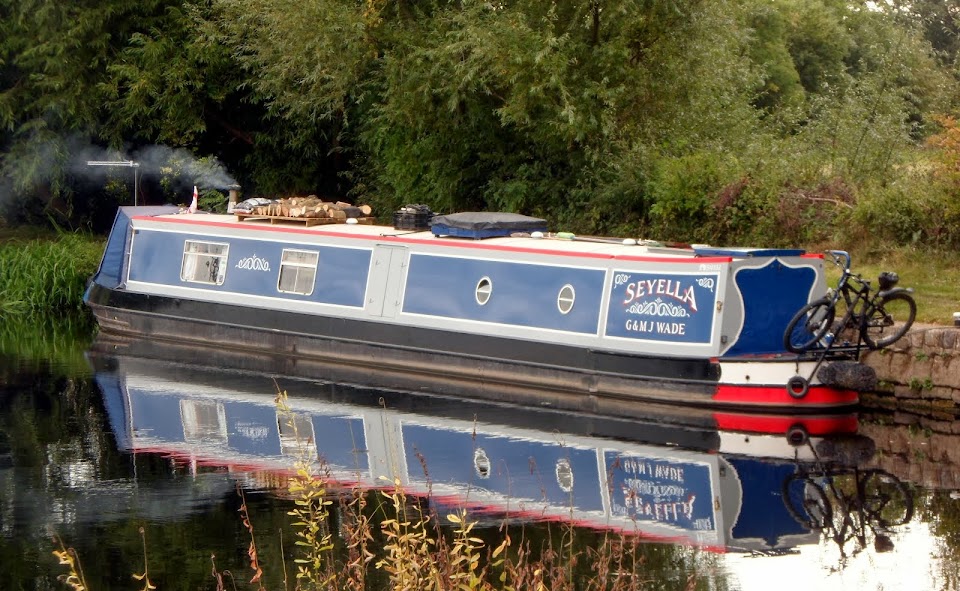
Moored at Boroughbridge

It’s not a perfect mooring here, high banks and a narrow towpath. But we’ve been on worse.
When I came to set up the TV aerial I discounted the south-westerly Yorkshire transmitter because of the bank on the left. It looked better towards the Teeside mast, to the north-east. I was surprised to discover we could only get BBC channels on digital, investigation revealed that this transmitter has yet to change from analogue, and is due to swap over completely tomorrow. I thought all of the UK had been done long since. So Mags is watching Emmerdale on a slightly spotty analogue picture, the first time in ages.
We’re maybe stopping here for two nights, we’ve guests arriving tomorrow and it depends on when they get here.
Locks 1, miles 9½
No comments:
Post a Comment